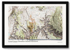
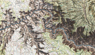


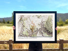
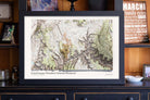
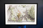


About The Map: This beautiful map is an exquisite piece of cartography that beautifully showcases one of the world's most awe-inspiring natural wonders. This topographic map is meticulously crafted using the latest digital mapping technologies and features highly detailed, three-dimensional terrain data that accurately represents the unique features and contours of the Grand Canyon.
The map is expertly shaded to simulate the interplay of light and shadow across the rugged landscape, highlighting the intricate geological formations and majestic plateaus that make up this breathtaking natural wonder. Whether you're a seasoned hiker, a curious traveler, or simply an admirer of the great outdoors, this map is the perfect addition to any home or office.
So why settle for a simple tourist map when you can experience the Grand Canyon in all its glory with the Shaded Relief Map of the Grand Canyon? Order yours today and discover the majesty and beauty of this natural wonder in a way you've never seen before!
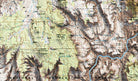
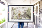
Product Format: This is a flat map with rich terrain depth to visualize the landscape. Although it looks 3-Dimensional it is produced as a flat map.
Map Size vs. Outside Dimensions: Our sizing choices specify the size of the map itself. Our frame options will increase the overall size of your final product depending on your selection.
For example:
Maps sized 24 x 16 inches will total 26.5 x 18.5 inches with the frame
Maps sized 30 x 20 inches will total 34 x 24 inches with the frame
Maps sized 36 x 24 inches will total 40 x 28 inches with the selection of a 2 inch frame
Maps sized 48 x 32 inches will total 52 x 36 inches with the selection of a 2 inch frame
For specific dimensions, see our page on Map Finish Options
Learn More: Check out our blog on Shaded Relief Maps to learn more about the art and science that goes into creating these beautiful maps.
Giant Map Bonus: All 48x32 inch, 60x40 inch, and 72x48 inch framed maps include 500 map pins, a special pin case, and some fun goodies to make the map even more special. Each GIANT map receives our special attention and individual oversight.
Production and Shipping Times: The amount of time it takes for your map to arrive depends on where you live and how fast you approve the proof if you’ve ordered a custom map. See Production & Shipping.
Quality and Guarantee: We stand behind our work and guarantee the construction and quality. Contact us if you have any problems with your map and we will coordinate to ensure you are very happy with your purchase.