


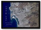
A stunning map that was created by a professional Geographer showing the amazing sights across the USA. Made in the USA by USA Small Business in Pleasanton, CA. Quick production and shipping.
Rolled Poster Edition: Fine Art Satin Finish
Each map includes clear plastic tube with end caps - perfect for keeping the map protected while traveling (each tube cost us $4 and is a huge value for you and your customers).
24x16" Map (Case of 30)
Single Value: $15 WSP / $40 MSRP
Case Value: $450 WSP / $1,200 MSRP
Individual Tube size: 2" x 20", weight: 8 oz
36x24" Map (Case of 13)
Single Value: $20 WSP / $59 MSRP
Case Value: $286 WSP / $767 MSRP
Individual Tube size: 2" x 38", weight: 8 oz
Plus the Free Mounted Display Map & About the Map Sign.
Production Time: 5 business days
Estimated Shipping Time: 3-5 business days
Note: Multiple boxes can arrive on different days.
