Wholesale Explore America Map - Brown Edition

$450.00

Most orders ship next day!

Standard maps will enter production right away, within the next business day. Larger orders may take more time.

All push pin board maps (framed or canvas wrap) include push pins, are easy to hang, and ship free in the continental US. We'll select the optimal shipping method for fast delivery.

For personalized maps we collaborate closely to guarantee satisfaction. Expect a proof to be sent to you. Your swift responses will facilitate the production and shipping process.

30 Day Returns

If there are any problems with your map we will take care of you. Returns for all maps are straightforward and hassle-free.

For personalized maps, engaging with the email proofs we send ensures that the final product meets your expectations precisely.

We have 30+ years of cartography experience, meticulously craft each order by hand to ensure excellence, and 100% guarantee your satisfaction. We produce maps that are built to last, with state of the art production and archival quality materials.

Personalize Your Map

Customize with quotes, legends, or dedications using "Personalize Map" options to craft your masterpiece map. Or reach out to us if you don't see the option you want.

We collaborate with you from design to approval of your proof so that you are 100% happy before we print and ship.

Our excellent customer service is always open to you.

Wholesale Explore America Map Prints

Explore America Map:  Brown Edition

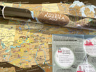
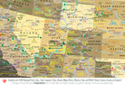
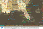
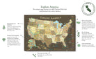
A highly-detailed map that features the 63 National Parks and over 600 NPS sites including: National Monuments, Historical Sites, National Memorials, Scenic National Trails, and more! Ideal for Visitor Centers, Tourist Shops, RV Dealerships, Museums, Bookstores, and Educational Shops. A stunning map that was created by a professional Geographer showing the amazing sites across the USA. Made in the USA by USA Small Business in Pleasanton, CA. Quick production and shipping.  

24x16" Map (Case of 30)

Single Value: $15 WSP / $40 MSRP

Case Value: $450 WSP / $1,200 MSRP

Individual Tube size: 2" x 20", weight: 8 oz

36x24" Map (Case of 15)

Single Value: $20 WSP / $59 MSRP
Case Value: $300 WSP / $885 MSRP
Individual Tube size: 2" x 38", weight: 8 oz

Map Features:

✦ Major cities, highways, lakes, and rivers
✪ USA State Capitals
✪ All 63 US National Parks
✦ National Forests & Monuments
✦ Historical Cities & locations
✪ NASA Visitor Centers
✦ Extraordinary Places (Golden Gate Bridge, Hoover Dam, Niagara Falls, and more)
▲Tallest elevation in every state - numbered from the highest (1 in Alaska) to lowest elevation (50 in Florida).
▲10 of the most climbed peaks in the U.S.A. with the peak name and elevation in feet.
●●● National Scenic Trails throughout the USA

Plus the Free Mounted Display Map & About the Map Sign.

Production Time:  5 business days

Estimated Shipping Time: 3-5 business days

USA Push Pin Travel Map

Track and plan your adventures with our National Parks Push Pin Maps!

USA Push Pin Travel Map

Track and plan your adventures with our National Parks Push Pin Maps!

Attention Visitor Centers!

Featured in the Theodore Roosevelt National Park Visitor Center in North Dakota

  • Feature Explore America in your visitor centers and shops.
  • Create an amazing interactive display, where visitors can pin where they came from and see where others have traveled from.

Ideal for National Park Travelers!

  • Perfect for National Park visitors and travelers.
  • One of the most comprehensive National Parks Map ever made.
  • Created by a professional geographer/cartographer, the research and design for this USA map took over a year.
  • Map has a unique referencing system has been developed for areas that have many National Park Service sites and a unique colored coded label system has been created on the side.

Attention Visitor Centers!

  • Explore America in your visitor centers and shops.
  • Create an amazing interactive display, where visitors can pin where they came from and see where others have traveled from.

Featured in the Theodore Roosevelt National Park
Visitor Center in North Dakota

Find Fascinating Travel Destinations

  • Our USA maps include more than the 63 National Parks! The map features over 600 NPS Historical Sites, National Monuments, NPS Wildlife Preserves, Historical Battlefields, and you can trace the path of the National Scenic Trails such as the Appalachian Trail and more!
  • Our detailed geography also includes state capitals, major cities, rivers, mountains, the U.S. interstate system, historical cities, NASA Space Centers, and much more. Explore fascinating travel destinations and find ideas for your next USA road trip!

Ideal for National Park Travelers!

  • Perfect for National Park visitors and travelers.
  • One of the most comprehensive National Parks Map ever made.
  • Created by a professional geographer/cartographer, the research and design for this USA map took over a year.
  • Map has a unique referencing system has been developed for areas that have many National Park Service sites and a unique colored coded label system has been created on the side.