


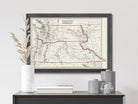


This map is a faithful reproduction of the original 1850 map restored to its former glory using the latest digital imaging technology.


Vintage State of Washington & Oregon Map
$39.00
Unit price
/
Unavailable
Standard maps will enter production right away, within the next business day. Larger orders may take more time.
All push pin board maps (framed or canvas wrap) include push pins, are easy to hang, and ship free in the continental US. We'll select the optimal shipping method for fast delivery.
For personalized maps we collaborate closely to guarantee satisfaction. Expect a proof to be sent to you. Your swift responses will facilitate the production and shipping process.
If there are any problems with your map we will take care of you. Returns for all maps are straightforward and hassle-free.
For personalized maps, engaging with the email proofs we send ensures that the final product meets your expectations precisely.
We have 30+ years of cartography experience, meticulously craft each order by hand to ensure excellence, and 100% guarantee your satisfaction. We produce maps that are built to last, with state of the art production and archival quality materials.
Customize with quotes, legends, or dedications using "Personalize Map" options to craft your masterpiece map. Or reach out to us if you don't see the option you want.
We collaborate with you from design to approval of your proof so that you are 100% happy before we print and ship.
Our excellent customer service is always open to you.
Restored 1850's Map
Fine Art Quality
Impressively produced with Archival Inks, Rich Color Depth, and clear and vivid labels. We use premium matte paper.
Expert Craftsmanship
We prepare the map using Fine Art Giclee production techniques. We roll the map in a sturdy tube for shipping to provide a crease-less piece of art.
Vintage State of Washington & Oregon Map
- Description
- Specs & Construction
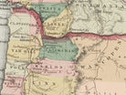
About the Map: Explore the geographic history of the state of Washington & Oregon in this historic map. This map is part of our vintage USA State Map Collection showing the geography of the states in the 1850-1860s and the time of the Civil War.
Restoration: The map is a reproduction of the original map meticulously restored to its former glory using the latest digital imaging technology. Using this technology, we carefully restored the colors, torn edges, creases, smeared writings and more. We enhanced features while keeping the original character and design of the map.
This map is unframed, sold as an art print. Frames are shown for illustration ONLY.
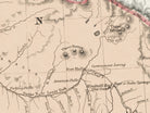
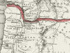
Geographic Details: This historic map shows many details of towns, roads, railroads, and waterways in the 19th century of the United States.
Shows historic cities such as Seattle, Tacoma, Portland and more!
Explore the historic boundaries of the cities, counties, and states that have changed over the years. Discover physical changes in the geography - such as former lakes and canals used for transportation and agriculture.
Available Sizes: For an impressive display and maximum readability, choose the largest size available.
Smaller size prints make excellent wall art in groups. Please note that there is no guarantee that small text will be legible in print.
Great Gift For:
Interior Designs, Teachers, History Buffs, Anniversaries, Birthdays, Friends, Family, and many more!
Production and Shipping Times: The amount of time it takes for your map to arrive depends on where you live and how fast you approve the proof if you’ve ordered a custom map. See Production & Shipping.
Quality and Guarantee: We stand behind our work and guarantee the construction and quality. Contact us if you have any problems with your map and we will coordinate to ensure you are very happy with your purchase.
Materials and Production: This reproduction is printed on Fine Art Museum Quality Paper with giclée inks. The thick paper is archival quality and acid-free with vivid color definition.
Paper details:
- 10 mil thick
- 230 gsm weight
- Museum Quality Matte finish
Made in the USA by a USA Small Business and Professional Geographer & Cartographer.
Shipped in a tube and rolled to eliminate creases.

Why choose GeoJango Maps
- We have a lifelong passion for maps, backed by 30+ years of cartography experience and Master's Degrees in Geographic Information Systems (GIS) from Penn State University and Environmental Science from the University of South Florida.
- Our incredible investment into the design of our maps results in unparalleled detail that matters: they will educate you, and grow with you as you travel the world and track your travels—where other maps miss the mark.
- We’ve built the leading map production studio in the USA and use exclusively USA-made materials. Each pin map is proudly crafted by hand, printed by us on the finest materials, mounted on museum-quality Gatorfoam, and carefully framed just for you.
History of the Time
The 1850s were a period of rapid change, expansion, and transformation in the history of Washington and Oregon territories, as they navigated economic growth, political developments, cultural shifts, and their role in the broader context of westward expansion.
Economically, the 1850s marked a turning point in the economic landscapes of Washington and Oregon territories. Both territories were known for their abundant natural resources, fertile lands, and strategic locations for trade. The gold rush of the 1850s drew prospectors seeking fortunes to the region, resulting in the establishment of mining camps and towns.
Oregon's Willamette Valley became a hub for agricultural development, as settlers cultivated crops such as wheat and hops. In Washington, logging emerged as a significant industry, harnessing the region's vast timber resources. The establishment of ports and the improvement of transportation networks, including the Oregon Trail and water routes, facilitated trade and economic growth.
Politically, the 1850s were marked by the territories' path toward statehood and their engagement with national debates. Oregon was admitted to the Union as the 33rd state in 1859, while Washington remained a territory. The issue of slavery was less prominent in these territories compared to other parts of the nation, but political divisions over other issues, such as land rights and government policies, played out within their boundaries.
Cultural and social developments were also notable during the 1850s. Both territories attracted settlers from various backgrounds seeking new opportunities. European immigrants, including Scandinavian and German communities, contributed to the cultural diversity of the region. The development of educational institutions, such as the University of Washington and Willamette University, demonstrated a commitment to intellectual growth.
As the 1850s came to a close, Washington and Oregon territories were positioned to play a role in the unfolding events of the following decades. The growing populations and economic activities laid the foundation for their future statehood and influence within the growing nation.
The Civil War of the 1860s would impact both territories, as they provided resources and support to the Union war effort. Washington's strategic location and Oregon's resources were essential to the overall Union strategy on the West Coast.
In conclusion, the 1850s were a transformative period for Washington and Oregon territories, characterized by economic growth, political developments, and cultural shifts. Their paths toward statehood, engagement with national debates, and contributions to the broader narrative of westward expansion highlighted their evolving identities and significance within the history of the United States.