


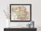
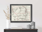

This map is a faithful reproduction of the original 1850 map restored to its former glory using the latest digital imaging technology.


Vintage State of New Mexico & Utah Map
$39.00
Unit price
/
Unavailable
Standard maps will enter production right away, within the next business day. Larger orders may take more time.
All push pin board maps (framed or canvas wrap) include push pins, are easy to hang, and ship free in the continental US. We'll select the optimal shipping method for fast delivery.
For personalized maps we collaborate closely to guarantee satisfaction. Expect a proof to be sent to you. Your swift responses will facilitate the production and shipping process.
If there are any problems with your map we will take care of you. Returns for all maps are straightforward and hassle-free.
For personalized maps, engaging with the email proofs we send ensures that the final product meets your expectations precisely.
We have 30+ years of cartography experience, meticulously craft each order by hand to ensure excellence, and 100% guarantee your satisfaction. We produce maps that are built to last, with state of the art production and archival quality materials.
Customize with quotes, legends, or dedications using "Personalize Map" options to craft your masterpiece map. Or reach out to us if you don't see the option you want.
We collaborate with you from design to approval of your proof so that you are 100% happy before we print and ship.
Our excellent customer service is always open to you.
Restored 1850's Map
Fine Art Quality
Impressively produced with Archival Inks, Rich Color Depth, and clear and vivid labels. We use premium matte paper.
Expert Craftsmanship
We prepare the map using Fine Art Giclee production techniques. We roll the map in a sturdy tube for shipping to provide a crease-less piece of art.
Vintage State of New Mexico & Utah Map
- Description
- Specs & Construction
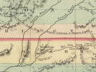
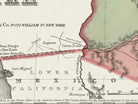
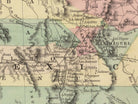
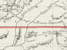
About the Map: Explore the geographic history of the state of New Mexico & Utah in this historic map. This map is part of our vintage USA State Map Collection showing the geography of the states in the 1850-1860s and the time of the Civil War.
Restoration: The map is a reproduction of the original map meticulously restored to its former glory using the latest digital imaging technology. Using this technology, we carefully restored the colors, torn edges, creases, smeared writings and more. We enhanced features while keeping the original character and design of the map.
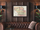
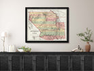
This map is unframed, sold as an art print. Frames are shown for illustration ONLY.
Geographic Details: This historic map shows many details of towns, roads, railroads, and waterways in the 19th century of the United States.
Shows historic cities such as Santa Fe, Albuquerque, Salt Lake City and more!
Explore the historic boundaries of the cities, counties, and states that have changed over the years. Discover physical changes in the geography - such as former lakes and canals used for transportation and agriculture.
Available Sizes: For an impressive display and maximum readability, choose the largest size available.
Smaller size prints make excellent wall art in groups. Please note that there is no guarantee that small text will be legible in print.
Great Gift For: Interior Designs, Teachers, History Buffs, Anniversaries, Birthdays, Friends, Family, and many more!
Production and Shipping Times: The amount of time it takes for your map to arrive depends on where you live and how fast you approve the proof if you’ve ordered a custom map. See Production & Shipping.
Quality and Guarantee: We stand behind our work and guarantee the construction and quality. Contact us if you have any problems with your map and we will coordinate to ensure you are very happy with your purchase.
Materials and Production: This reproduction is printed on Fine Art Museum Quality Paper with giclée inks. The thick paper is archival quality and acid-free with vivid color definition.
Paper details:
- 10 mil thick
- 230 gsm weight
- Museum Quality Matte finish
Made in the USA by a USA Small Business and Professional Geographer & Cartographer.
Shipped in a tube and rolled to eliminate creases.

Why choose GeoJango Maps
- We have a lifelong passion for maps, backed by 30+ years of cartography experience and Master's Degrees in Geographic Information Systems (GIS) from Penn State University and Environmental Science from the University of South Florida.
- Our incredible investment into the design of our maps results in unparalleled detail that matters: they will educate you, and grow with you as you travel the world and track your travels—where other maps miss the mark.
- We’ve built the leading map production studio in the USA and use exclusively USA-made materials. Each pin map is proudly crafted by hand, printed by us on the finest materials, mounted on museum-quality Gatorfoam, and carefully framed just for you.
History of the Time
The 1850s were a significant and transformative period in the history of New Mexico and Utah territories, marked by territorial expansion, cultural changes, and the challenges posed by the shifting political and social landscapes.
New Mexico and Utah were both part of the vast southwestern region of the United States during this period, and their histories were influenced by a mix of indigenous cultures, Spanish colonial heritage, and the influx of American settlers.
In the 1850s, both territories were at the center of debates surrounding the expansion of slavery and the political division between the North and the South. The Compromise of 1850, which aimed to balance the interests of free and slave states, impacted these territories as well. The compromise allowed for popular sovereignty in Utah and New Mexico, giving their residents the right to decide on the issue of slavery through local votes.
Culturally, the territories were characterized by a rich tapestry of indigenous, Hispanic, and Anglo-American influences. In New Mexico, the legacy of Spanish colonization was deeply rooted in the culture, architecture, and traditions. In Utah, the influence of the Church of Jesus Christ of Latter-day Saints (Mormon Church) was significant, with Brigham Young leading Mormon settlers to establish communities and develop infrastructure.
The 1850s marked a period of settlement and growth in both territories. In Utah, the establishment of Salt Lake City and other Mormon settlements played a crucial role in the development of the region. In New Mexico, the influx of American settlers and traders contributed to the growth of towns and trading posts.
The economic landscape of both territories was diverse. In New Mexico, ranching, agriculture, and trade with Mexico were important economic activities. In Utah, the development of agriculture, mining, and manufacturing industries contributed to economic growth.
As the 1850s came to a close, the territories were positioned to play a role in the significant events that lay ahead. Utah's history became intertwined with the national debates over polygamy and the federal government's attempts to exert control over the Mormon Church. The Utah War of the late 1850s reflected the tensions between the territory's religious leadership and the federal government.
In New Mexico, the Civil War of the 1860s would have a significant impact as the territory was caught between Confederate and Union forces due to its strategic location along the Santa Fe Trail.
In conclusion, the 1850s were a transformative period in the histories of New Mexico and Utah territories. These territories navigated issues of slavery, cultural diversity, and economic development within the broader context of national debates and territorial expansion. The legacies of Spanish colonization, indigenous cultures, and religious influences shaped their identities and roles within the unfolding narrative of American history.