


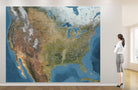
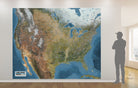
North America Wall Mural Map – Satellite Topographic Map with USA, Canada, Mexico & Roads
Standard maps will enter production right away, within the next business day. Larger orders may take more time.
All push pin board maps (framed or canvas wrap) include push pins, are easy to hang, and ship free in the continental US. We'll select the optimal shipping method for fast delivery.
For personalized maps we collaborate closely to guarantee satisfaction. Expect a proof to be sent to you. Your swift responses will facilitate the production and shipping process.
If there are any problems with your map we will take care of you. Returns for all maps are straightforward and hassle-free.
For personalized maps, engaging with the email proofs we send ensures that the final product meets your expectations precisely.
We have 30+ years of cartography experience, meticulously craft each order by hand to ensure excellence, and 100% guarantee your satisfaction. We produce maps that are built to last, with state of the art production and archival quality materials.
Customize with quotes, legends, or dedications using "Personalize Map" options to craft your masterpiece map. Or reach out to us if you don't see the option you want.
We collaborate with you from design to approval of your proof so that you are 100% happy before we print and ship.
Our excellent customer service is always open to you.
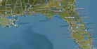
🧭 North America Wall Mural Map – Giant GIS-Based Satellite Map for Home, Office, and Business Display
Explore North America like never before with this stunning large-format wall mural map, meticulously designed by professional geographers using advanced GIS (Geographic Information Systems) and remote sensing technology. This is not just a decorative print — it's a data-rich visualization crafted from high-resolution satellite imagery, enhanced terrain modeling, and detailed cartographic research.
🛰️ Designed by GIS Experts – Not Mass-Produced. Original geographic art and science for your visualization.
GeoJango Maps are designed by professional geographers using Esri GIS software and NASA/ESA remote sensing data. This unique expertise allows us to deliver superior geographic accuracy, data integration, and terrain realism that’s unmatched in the marketplace.
Map Size: 10 ft wide by 8 ft tall (height). The size of the map can be customized. Contact us for special requests.
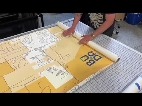
Materials: Textured Wall Decal (commercial grade peel and stick) is stunning. The map is produced on a durable fabric that has a peel and stick adhesive backing. The map can be removed from the wall and re-used - ideal for rented spaces.
Adhesive Backed Panels: The map will be divided into THREE 40 inch rolled panels. The map includes a peal and stick backing that is easy to apply.
Customizations: We can add a logo, map title, subtitle, quote, legend, scale bar, compass to your map. Proofs will be provided for your review and you are welcome to ask for any changes so the map meets your vision.
🌎 Features You’ll Only Find in a GeoJango Map:
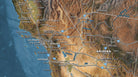
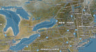
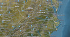
Geography Extent: From the lower Canadian Provinces to Baja, Mexico
✅ Advanced Topographic Detail:
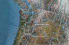
Includes hillshade terrain modeling, digital elevation data, and land cover variation to reveal mountain ranges, plateaus, and river systems across the U.S., Canada, and Mexico.
✅ Major Roads and Highways:
Labeling includes interstates, transnational highway systems, and key routes—ideal for logistics planning, travel routing, or business operations.
✅ City & Capital Markers:
Clearly identifies major cities, capitals, and regional hubs, helping users visualize urban footprints and population distribution.
✅ Geopolitical Boundaries:
• USA State Borders
• Canada’s Provincial Borders
• Mexico’s State Lines
• Great Lakes Region and Coastlines
✅ Highly Customizable:
Add your company locations, project sites, or custom labeling for personal or business use. Perfect for conference rooms, educational spaces, or RV travel planning.
✅ Precision Coastlines:
We include incredibly detailed shoreline and lake edge data—features that many map makers ignore due to the complexity of rendering.
🎯 Ideal For:
-
Travel Enthusiasts and RV Owners
-
Corporate Logistics and Operations Teams
-
Educators and Geography Teachers
-
Interior Designers and Art Buyers
-
Government and Military Planning Rooms
------
Timing: Your map will be scheduled for production within 48 hours of our approval (weekdays). Shipping is 2 to 5 days depending on your location. Let us know if you need expedited shipping.
Satisfaction Guarantee: We hope you will be thrilled with the maps! If there are any problems, we are here to help to your satisfaction.
-
Not a mass-produced or offshore print—crafted by GIS professionals in California using real satellite data.
-
Each map is created on demand in our state-of-the-art cartography studio. This is geographic art, not stock decor.
-
Pricing includes U.S. shipping and supports our small, woman-owned business and local production team.
About GeoJango Maps:
We are professional Cartographers and Geographers with advanced degrees in GIS (Master's in GIS and Master's in Environmental Science). Our passion is to make maps and geography material to inspire people to learn more about the world. We created the nation's best Map Studio with state of the art Fine Art Equipment exclusively for the production of our maps. We use 100% Made in the USA Products. Our business and production is located in Pleasanton, CA.
Thank you for purchasing from a USA Small Business!

Why choose GeoJango Maps
- We have a lifelong passion for maps, backed by 30+ years of cartography experience and Master's Degrees in Geographic Information Systems (GIS) from Penn State University and Environmental Science from the University of South Florida.
- Our incredible investment into the design of our maps results in unparalleled detail that matters: they will educate you, and grow with you as you travel the world and track your travels—where other maps miss the mark.
- We’ve built the leading map production studio in the USA and use exclusively USA-made materials. Each pin map is proudly crafted by hand, printed by us on the finest materials, mounted on museum-quality Gatorfoam, and carefully framed just for you.