HNL - Daniel K. Inouye Airport Runway Map

$29.00

Most orders ship next day!

Standard maps will enter production right away, within the next business day. Larger orders may take more time.

All push pin board maps (framed or canvas wrap) include push pins, are easy to hang, and ship free in the continental US. We'll select the optimal shipping method for fast delivery.

For personalized maps we collaborate closely to guarantee satisfaction. Expect a proof to be sent to you. Your swift responses will facilitate the production and shipping process.

30 Day Returns

If there are any problems with your map we will take care of you. Returns for all maps are straightforward and hassle-free.

For personalized maps, engaging with the email proofs we send ensures that the final product meets your expectations precisely.

We have 30+ years of cartography experience, meticulously craft each order by hand to ensure excellence, and 100% guarantee your satisfaction. We produce maps that are built to last, with state of the art production and archival quality materials.

Personalize Your Map

Customize with quotes, legends, or dedications using "Personalize Map" options to craft your masterpiece map. Or reach out to us if you don't see the option you want.

We collaborate with you from design to approval of your proof so that you are 100% happy before we print and ship.

Our excellent customer service is always open to you.

Honolulu Airport Map

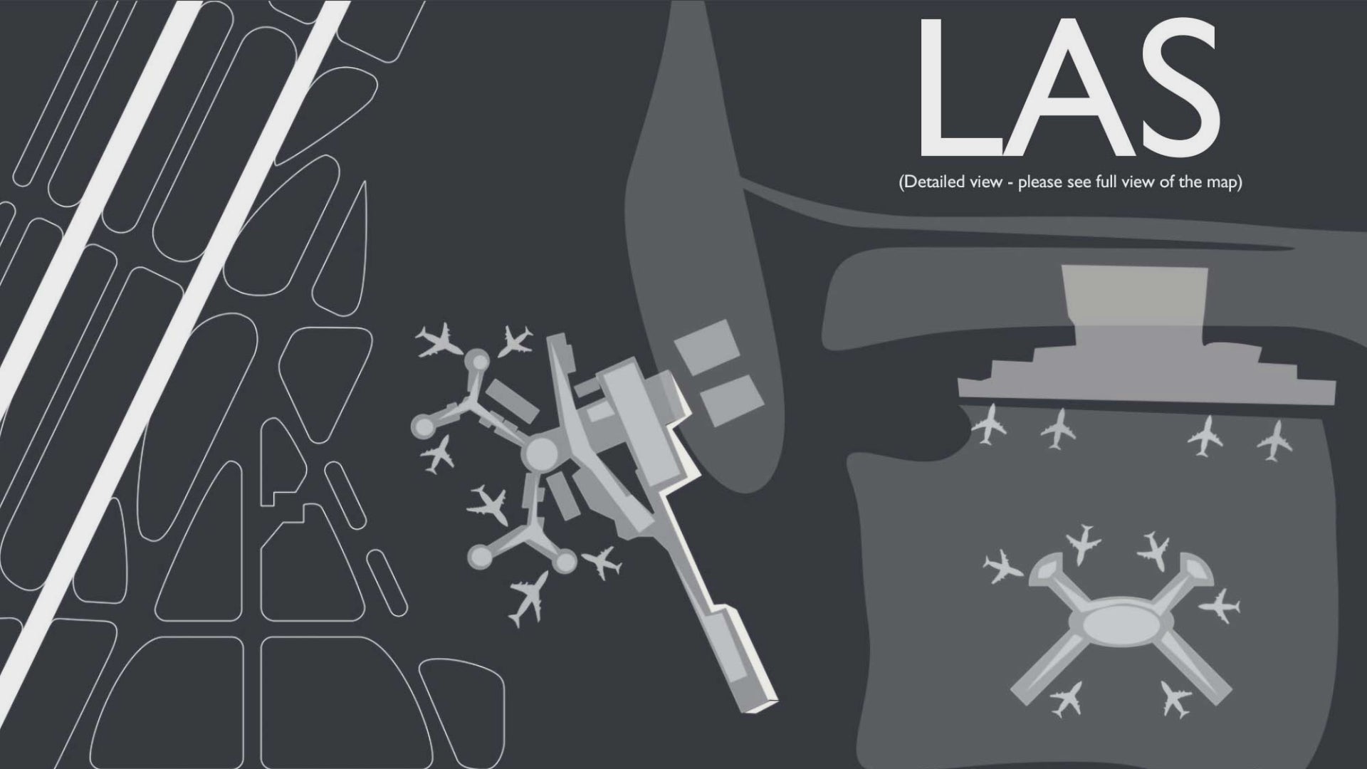
Take a trip to the beautiful island of Oahu, Hawaii and fly into HNL Airport! Also known as Honolulu International airport, this busy airport serves as the principal aviation gateway for Hawaiian residents, tourists, and cargo. The airport provides quick access to the city of Honolulu and is situated on the southern shore of the island of Oahu.

When flying into Honolulu airport, you have a bird’s eye view of the surrounding Hawaiian Islands and the Pacific Ocean. Try to spot wildlife in the oceans and the unique geography of the surrounding islands including the rainforests, volcanoes, and beautiful cliffs and beaches. Above Oahu, one may see Waikiki Beach, Pearl Harbor and the striking view of Diamond Head, an ancient volcano near Waikiki that one can climb.  

From Honolulu’s airport you can hop on an airplane to visit:

Island of Hawai’i: Kona International Airport at Keahole, Hilo International Airport and Waimea-Kohala Airport

Maui: Kahului Airport, Kapalua Airport and Hana Airport.  

Kaua’i: Lihu’e Airport

Lana’i: Lana’i Airport

Molokai: Molokai Airport and Kalaupapa Airport

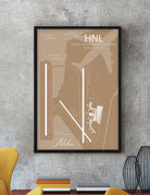
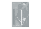
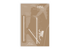
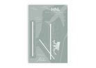
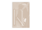
Bring the airport that serves the Aloha State to life features accurate GIS mapping technology, unique artist effects, terminals, and impressive details that are fun to explore. This airport map will delight you and your walls with happy memories of your travels and adventures.

About The Map: At GeoJango, we are experts in GIS and developing accurate maps. We use satellite imagery and GIS modeling techniques to accurately model the layout and composition of each airport. We take great care in modeling the airport runways, infrastructure, terminals, and surrounding landscape. We capture accurate runway orientations, lengths, and landscape features to scale - however the maps are not intended for navigation purposes.   For a unique touch, we combine professional GIS, cartography, 3D illustration, and artistry to highlight the features of each airport.   The result: impressive illustrations of each airport that is fun to explore and beautiful to display!

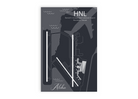
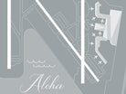
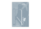
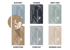
Style Options: Our Airport Map Poster comes in 6 design options: Blue Mist, Thunder, Minty Dew, Sandstorm, Overcast, and Morning Haze.

Blue Mist - This style reflects a bright blue sky, and will bring the color of a sunny day into any room.

Thunder - Our deepest slate-colored style is a favorite for its bold contrast that pops in any space.

Minty Dew - Earth-toned and beautiful, the minty green color spreads a crisp sense of serenity wherever it goes.

Sandstorm - This warm style reflects a cozy yet sophisticated feel that will complement your space perfectly.

Overcast - Our muted grey style is calming and gentle. This style is great for those who love rainy days and neutral aesthetics.

Morning Haze - Bright and serene, this shade radiates a neutral glow perfect for those who love light colors.

Construction:

Our maps are printed on high-quality photo satin paper with archival inks and shipped in a tube. All of our maps are produced entirely in the USA and shipped directly by us to your shipping destination.

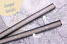
Poster Hanger option:

The magnetic poster hangers are easy to hang, modern and easy to transport. The hangers are made with sustainable wood and strong super-magnets. The top hanger includes a leather lace for hanging. Simply place the map between the hangers and they will snap and align perfectly together on the top and the bottom of the map.

The hangers are available in 12 inch, 16 inch, 20 inch, and 24 inch widths. Choose from either modern black, teak wood, brushed grey, and clean white.

Portrait Orientation: Select the shorter side for the hanger size.

12x18 inches = 12 inch hanger

16x24 inches = 16 inch hanger

20x30 inches = 20 inch hanger

24x36 inches = 24 inch hanger

*Hanger not available for 32x48 inch map, however you can purchase two 24 inch hangers*

Applications:

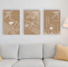
Decorate your home, office, dorm room, vacation home, or Airbnb with your favorite airports.

Delight your guests with a beautiful airport diagram of your local airport.

A Great Gift For:

Travelers, pilots, aeronautical engineers, airport service workers, and aviation lovers! This is the perfect wedding, graduation, birthday, or holiday gift for everyone!

Quality & Guarantee:

We stand behind our work and guarantee the highest level of construction and quality. Contact us if you have any problems with your map and we will coordinate to ensure you are happy with your order.

History of the Airport

Daniel K. Inouye International Airport, formerly known as Honolulu International Airport, is one of the busiest airports in the United States and serves as the primary gateway to Hawaii. Situated on the island of Oahu, this airport plays a vital role in connecting the Hawaiian Islands to the rest of the world. To efficiently manage the complex operations of an airport of this scale, a detailed runway map is essential.

The Daniel K. Inouye Airport Runway Map is a crucial navigational tool for pilots, air traffic controllers, and airport personnel. It provides a comprehensive overview of the airport's runway layout, taxiways, and related infrastructure, ensuring safe and efficient aircraft movements on the ground and during takeoff and landing.

One of the standout features of the Daniel K. Inouye Airport Runway Map is its extensive runway system. The airport boasts four major runways, each designed to accommodate various types of aircraft. These runways are strategically positioned to account for prevailing wind patterns, providing pilots with optimal takeoff and landing options. The map clearly illustrates the orientation and dimensions of each runway, helping pilots make informed decisions based on wind direction and aircraft performance.

Furthermore, the runway map provides detailed information on the various taxiways that connect the runways to the airport's terminals, cargo areas, and maintenance facilities. This intricate network of taxiways is crucial for the efficient flow of aircraft on the ground. Air traffic controllers rely on the map to guide aircraft to their designated gates, runways, or holding areas, minimizing congestion and ensuring the safety of all operations.

Safety is paramount in aviation, and the Daniel K. Inouye Airport Runway Map contributes significantly to this aspect. It displays the locations of runway lighting, signage, and other essential visual aids that assist pilots during low-visibility conditions, such as fog or heavy rain. This information is invaluable for ensuring safe landings and departures, especially in Hawaii's tropical climate, which can experience rapid weather changes.

In addition to serving as a navigational aid for pilots and air traffic controllers, the runway map also plays a crucial role in emergency planning and response. It clearly marks the locations of emergency exits, firefighting equipment, and other safety features that are vital in the event of an aircraft emergency. Quick and accurate access to this information is essential for the airport's emergency response teams, who must be prepared to react swiftly to any unforeseen situations.

The Daniel K. Inouye Airport Runway Map also reflects the airport's commitment to environmental sustainability. It highlights designated areas for aircraft deicing, where eco-friendly practices are implemented to minimize the environmental impact of this necessary procedure. This emphasis on environmental responsibility aligns with Hawaii's unique ecosystem and its dedication to preserving its natural beauty.

Additionally, the runway map serves as a reference point for airport maintenance and expansion projects. As airports evolve to accommodate increasing passenger and cargo traffic, the map can be updated to reflect changes in runway configurations or the addition of new taxiways and infrastructure. This adaptability is crucial for ensuring that the airport can meet the growing demands of the aviation industry while maintaining high safety standards.

In conclusion, the Daniel K. Inouye Airport Runway Map is an essential tool for the safe and efficient operation of one of the United States' busiest airports. It provides critical information for pilots, air traffic controllers, and airport personnel, contributing to the airport's reputation for excellence in aviation services. As air travel continues to play a vital role in connecting Hawaii to the world, the importance of this runway map cannot be overstated, as it ensures that the skies over the Hawaiian Islands remain safe and accessible to all.