Custom Business Satellite Map South Carolina
Couldn't load pickup availability
Custom Satellite Map of Greater Charleston Area
Map Dimensions: 84" wide × 60" tall
Geographic Coverage
The map showcases the community of Charleston, SC
West: Edisto
North: Jedburg
East: Awendaw
South: Charleston
Shipping
-
Complimentary shipping included with your order
-
Estimated delivery: ~2 weeks (1 week for design + 1 week for production and shipping)
-
Production time: 2 business days after final approval and payment
-
Shipping time: 2-3 days
-
Materials
-
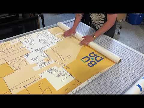
Material: Commercial-grade Poly-Textured Wall Decal
-
Finish: Peel-and-stick adhesive backing
- The map would be produced on two panels, both 30" wide by 84" tall.
-
Features:
-
Easy to apply
-
Nice to touch
-
100% Made in the USA
-
Ideal for office walls and durable enough for long-term display in high-traffic areas. The map can be touched and has a nice texture.
2nd Optional Map: Canvas Map with Grommets (as shown in the neighborhood map below.)
Map Content & Cartography
Includes up to 3 hours of custom GIS-based cartographic design, featuring:
- Professional Satellite Imagery
- Labeled cities and major roads (interstate and highways signs)
-
We can outline special areas such as counties.
Map Elements & Enhancements
-
Included: Title, scale bar, and north arrow
-
Optional Customizations: We can add your company logo, map title, subtitle, legend
Proofs & Revisions
Digital proofs will be provided for your review. You're welcome to request edits—we’ll ensure the map meets your exact specifications before production.
Satisfaction Guarantee
We want you to be absolutely thrilled with your map. If anything isn’t right, our team is here to make it right—your satisfaction is our priority.
About GeoJango Maps
-
We are a professional GIS and cartography team, proudly operating out of Pleasanton, California
-
Our maps are designed and produced in-house in one of the most advanced map production studios in the country
-
We are proud to be a USA-based small business that specializes in satellite imagery and GIS technology.


