


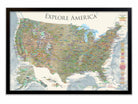
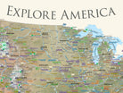
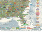


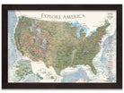
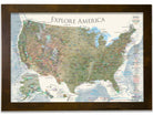
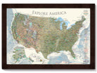
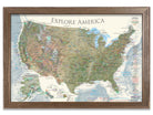
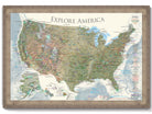
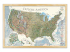

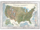

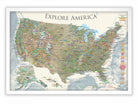

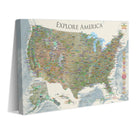


The USA National Parks Map provides a comprehensive reference to all of the 600+ National Park Sites, historical cities, landmarks, and interstates to plan your road trips.
What truly sets our maps apart is the depth of expertise and meticulous attention to detail that we bring to each creation. Our team's extensive background in Geography, Cartography, and GIS Data ensures that every map is not just a tool, but a comprehensive learning experience. As the leading Push Pin Map company in the USA—and indeed, globally—we pride ourselves on our commitment to in-depth research and advanced academic knowledge in the field.
Our maps are designed to grow with you, revealing more layers of information and insights as your familiarity and experience with them deepen.
With every use, you’ll discover new details and connections, making each map a continual source of discovery. Whether you're planning your next great adventure or exploring from the comfort of your home, our maps serve as a reliable resource for endless learning and exploration. This unique blend of official data, expert design, and educational richness makes our maps invaluable to anyone seeking to explore the world with accuracy and insight.
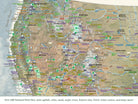
This USA travel map features a beautiful impression of 3D dimensions for the elevation and terrain of the USA. We modeled the terrain of the United States using USGS topological data. The 3D shading effects provide visual depth in the map, and natural landscape colorization is used to illustrate deserts, valleys, mountain ranges, planes, agriculture, and forested areas.
For the National Parks, we worked with the National Park Service to uniquely display and reference over 600 sites across the USA. Every reference has been thoroughly researched, symbolized, and carefully labeled on the map. A unique colored-coded label and legend will guide you on each reference.
Detailed USA Map Features:
✦ Significant landmarks locations across the USA
✦ Interstate Roads to plan and reference
✪ State Capitals Labeled
✪ Over 600 National Park Service Sites (features all 63 National Parks and outlines the boundaries)
✦ Labeled Major Rivers
✦ Historical Cities
✪ NASA Visitor Centers
✦ Extraordinary Places (Golden Gate Bridge, Hoover Dam, Niagara Falls, and more)
▲Tallest elevation in every state - numbered from the highest (1 in Alaska) to lowest elevation (50 in Florida).
▲10 of the most climbed peaks in the U.S. with the peak name and elevation in feet.
●●● For hikers, scout out the National Scenic Trails that cross the United States
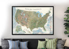
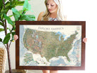
Framed Maps and Canvas Wrap Maps are specially made as durable pinnable map and include a whopping case of 500 push pins!
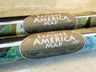
Poster Material Options: Select either photo satin paper or upgrade to our premium canvas material. All of our maps are made as Fine Artwork.
- Our Photo Satin Paper offers a modern smooth surface and made for rich color depth.
- Our Premium Canvas is a premium cotton canvas with a tight texture for vivid coloring.
Coordinating World Map: The Odyssey USA Map pairs with our Odyssey World Map. Both maps feature the same colors and extraordinary geographic details. They complement each other and together provide a comprehensive view of the world and the United States.
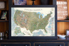
Travel Bloggers, Social Media Travel Blog:
Travel Bloggers, RV Campers, and Van Life Travelers: Use our expertly crafted maps to significantly expand your reach, appearing to a broader audience that values quality and professionalism in travel planning and geographic education.
Perfect Gift for travelers, hikers, campers, students, history lovers, and geography enthusiasts. The content is recommended for adults and youth who would like to learn more about the USA.
