MCO - Orlando Airport Runway Map

$29.00

Most orders ship next day!

Standard maps will enter production right away, within the next business day. Larger orders may take more time.

All push pin board maps (framed or canvas wrap) include push pins, are easy to hang, and ship free in the continental US. We'll select the optimal shipping method for fast delivery.

For personalized maps we collaborate closely to guarantee satisfaction. Expect a proof to be sent to you. Your swift responses will facilitate the production and shipping process.

30 Day Returns

If there are any problems with your map we will take care of you. Returns for all maps are straightforward and hassle-free.

For personalized maps, engaging with the email proofs we send ensures that the final product meets your expectations precisely.

We have 30+ years of cartography experience, meticulously craft each order by hand to ensure excellence, and 100% guarantee your satisfaction. We produce maps that are built to last, with state of the art production and archival quality materials.

Personalize Your Map

Customize with quotes, legends, or dedications using "Personalize Map" options to craft your masterpiece map. Or reach out to us if you don't see the option you want.

We collaborate with you from design to approval of your proof so that you are 100% happy before we print and ship.

Our excellent customer service is always open to you.

Airport in Florida

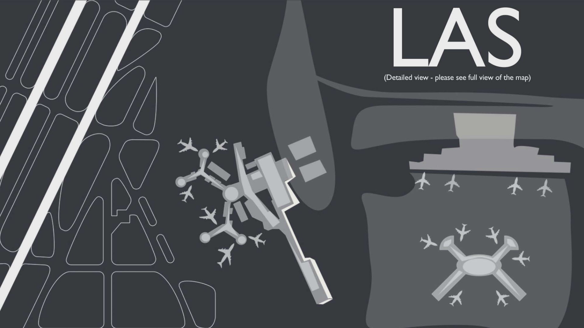
Being Florida’s busiest airport located in Orlando, MCO is a major gateway to Disney World and land of theme parks. MCO was originally named after the airport’s first name: McCoy Air Force Base. With the location’s relative proximity to Cuba, this was a front line airport during the Cold War and subsequently used for the Vietnam War.

The airport historically serves over 850 flights daily and is one of the largest commercial airports in reference to land area in the U.S.   Charish your fondest travel memories of the airport that serves the “Sunshine State” to life with our brand beautiful and accurate illustration of Orlando’s Airport.

MCO’s modern architecture is a delight to experience. When flying into and out of MCO, passengers can get a bird’s eye view of Orlando, Disney World’s wide complex, theme parks, orange groves, the multitudes of fresh water lakes of Florida’s central valley of water network that flows south to the Everglades. Situated only 40 minutes west of Cape Kennedy, one may get a glimpse of the Kennedy Space Center and Cape Canaveral.

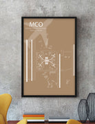
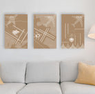
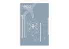
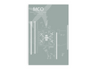
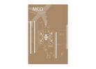
Our MCO Airport Diagram Wall Art features accurate GIS mapping technology, unique artist effects, terminals, and impressive details that are fun to explore. This airport map will delight you and your walls with happy memories of your travels and adventures.

About The Map: At GeoJango, we are experts in GIS mapping and developing products of the highest quality display. Each map art print is created using open street maps, a comprehensive worldwide database of roads, streets, and other features. We design each of our five unique styles by programming thousands of layers within each map. In turn, our maps are the most accurate, high-quality, and stylish on the market.

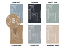
Style Options: Our Airport Map Poster comes in 6 design options: Blue Mist, Thunder, Minty Dew, Sandstorm, Overcast, and Morning Haze.

Blue Mist - This style reflects a bright blue sky, and will bring the color of a sunny day into any room.

Thunder - Our deepest color style is a crowd favorite for its bold contrast that pops in any space.

Minty Dew - Earth-toned and beautiful, this color style spreads a crisp sense of serenity wherever it goes.

Sandstorm - This warm style reflects a cozy yet sophisticated feel that will complement your space perfectly.

Overcast - Our muted grey style is calming and gentle. This style is great for those who love rainy days and neutral aesthetics.

Morning Haze - Bright and serene, this shade radiates a neutral glow perfect for those who love light colors.

Construction:

Our posters are printed on high-quality photo satin paper with archival inks and shipped in a tube. All of our maps are produced entirely in the USA and shipped directly to your home.

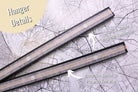
Posters with Hanger option:

- Portrait: 12"x18", 16"x24", 20"x30", and 24"x36"

The magnetic poster hangers come in 12inch, 16inch, 20inch, and 24inch width. Choose from either modern black, teak wood, brushed grey, and clean white.

*Hanger not available for 32"x48" map*

Applications:

Decorate your home, office, dorm room, or Airbnb with your favorite airport.

A Great Gift For:

Travelers, pilots, aeronautical engineers, airport service workers, and aviation lovers! This is the perfect wedding, graduation, birthday, or holiday gift for everyone!

Quality & Guarantee:

We stand behind our work and guarantee the highest level of construction and quality. Contact us if you have any problems with your map and we will coordinate to ensure you are happy with your order.

History of the Airport

Orlando International Airport, often referred to as MCO, is a major gateway to Central Florida and one of the busiest airports in the United States. To facilitate the safe and efficient movement of aircraft in and out of the airport, a detailed runway map is essential. The Orlando Airport Runway Map is a vital navigational tool for pilots, air traffic controllers, and airport personnel, ensuring that operations run smoothly in one of the Sunshine State's most important transportation hubs.

One of the primary features of the Orlando Airport Runway Map is its comprehensive layout of the airport's runways. Orlando International boasts four parallel runways, which are strategically oriented to accommodate various wind conditions. The map clearly illustrates the dimensions, headings, and designations of each runway, allowing pilots to select the most suitable runway for takeoff and landing based on wind direction and aircraft type.

Taxiways play a crucial role in airport operations, and the Orlando Airport Runway Map provides a detailed depiction of the extensive taxiway system. These taxiways connect the runways to the terminal buildings, cargo facilities, maintenance areas, and other essential parts of the airport. The map helps air traffic controllers guide aircraft to their designated gates or runways, ensuring that ground movements are coordinated and efficient.

Safety is paramount in aviation, and the Orlando Airport Runway Map includes essential information to enhance safety during aircraft operations. This information includes the locations of runway lighting, signage, and other visual aids that assist pilots during low-visibility conditions, such as fog or heavy rain. The map helps ensure that aircraft can safely navigate the airport's complex layout regardless of the weather.

In addition to safety considerations, the map is an essential resource for emergency response planning. It highlights emergency exit locations, firefighting equipment, and other critical safety features that are crucial in the event of an aircraft emergency. Airport personnel and emergency responders rely on the map to quickly locate and access these resources during emergencies, ensuring a rapid and coordinated response.

The Orlando Airport Runway Map also reflects the airport's commitment to environmental sustainability. It identifies designated areas for aircraft deicing, where eco-friendly practices are employed to minimize the environmental impact of this necessary procedure. Orlando International Airport is dedicated to reducing its carbon footprint and adhering to environmental regulations, and the map plays a role in supporting these efforts.

Moreover, the runway map serves as a valuable reference for airport maintenance and expansion projects. As Orlando International continues to grow and accommodate increasing passenger and cargo traffic, the map can be updated to reflect changes in runway configurations or the addition of new taxiways and infrastructure. This adaptability is essential for ensuring the airport can meet the evolving demands of the aviation industry while maintaining high safety standards.

In conclusion, the Orlando Airport Runway Map is a critical tool that underpins the safe and efficient operation of one of the nation's busiest airports. It provides essential information for pilots, air traffic controllers, and airport personnel, contributing to the airport's reputation for excellence in aviation services. As Orlando International Airport continues to be a key hub for travelers from around the world, the importance of this runway map cannot be overstated, as it plays a pivotal role in ensuring that the skies over Central Florida remain accessible, safe, and reliable.