Standard maps will enter production right away, within the next business day. Larger orders may take more time.
All push pin board maps (framed or canvas wrap) include push pins, are easy to hang, and ship free in the continental US. We'll select the optimal shipping method for fast delivery.
For personalized maps we collaborate closely to guarantee satisfaction. Expect a proof to be sent to you. Your swift responses will facilitate the production and shipping process.
30 Day Returns
If there are any problems with your map we will take care of you. Returns for all maps are straightforward and hassle-free.
For personalized maps, engaging with the email proofs we send ensures that the final product meets your expectations precisely.
We have 30+ years of cartography experience, meticulously craft each order by hand to ensure excellence, and 100% guarantee your satisfaction. We produce maps that are built to last, with state of the art production and archival quality materials.
Personalize Your Map
Customize with quotes, legends, or dedications using "Personalize Map" options to craft your masterpiece map. Or reach out to us if you don't see the option you want.
We collaborate with you from design to approval of your proof so that you are 100% happy before we print and ship.
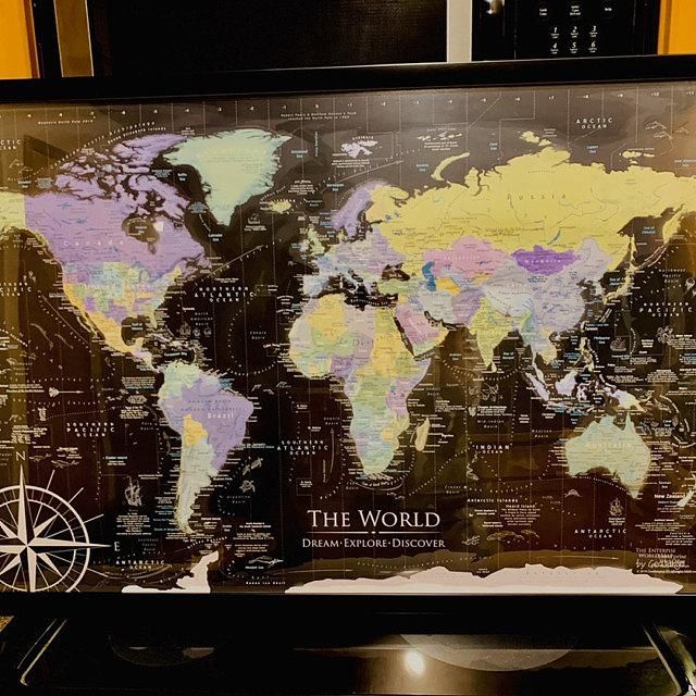
Enterprise World Map: Your Portal to the World's Wonders
Embrace the vibrant exploration of the globe with the Enterprise World Map, meticulously crafted by professional cartographers using advanced GIS mapping technology. This map is not just a visual treat but an educational tool, designed to track your travels and enliven any room with its bold color palette.
Vivid Design and Educational Excellence:
Striking Colors: Featuring deep shades of black, greens, blue, and violet, this map ensures to catch the eye and enhance the aesthetic of your home or office decor.
Rich Geographic Content: Delve into detailed features like the geography of countries, the majestic peaks across continents, and the mesmerizing flows of ocean currents.
Detailed Features for Enhanced Learning:
Comprehensive Labeling: Every country, state, ocean, sea, gulf, strait, basin, and ridge is precisely labeled, offering a thorough understanding of Earth's topography.
Prominent Landmarks: Marked are the tallest peaks, key national parks, and important natural wonders, ideal for educational purposes or planning your next adventure.
Beautiful Wall Art and Informative:
Educational Tool and Wall Decor: Whether used in a classroom to teach geography or hung in a living room as a piece of art, this map serves multiple purposes.
Conversation Starter: Perfect for sparking discussions about travel experiences, world cultures, and geographical knowledge.
Customizable and Interactive:
Travel Tracking: Ideal for marking past excursions or future travel plans, turning the map into a personalized journal of your adventures.
World Map Comparisons: Explore various map options through our detailed comparisons to find the perfect style that suits your preference.
The Enterprise World Map offers more than just a way to view the world—it invites interaction, education, and appreciation of our planet's diversity. Whether you're decorating a space or fueling a passion for travel, this map is an essential tool for anyone who values the beauty and intricacies of the world.
A Great Gift for: Travelers, Adventures, and geography enthusiasts. An impressive wedding or anniversary gift for travel lovers. The content is recommended for adults and youth who would like to learn more about the world.
Optionally Personalize your map: You can make it your own by adding a custom title, subtitle, legend, and our unique map compass. For ideas on custom titles, see the "Travel Quotes" section to the right on desktop or below on mobile.
Pinnable Maps: The Framed Push Pin Map and and Canvas Wrap maps are special made as a durable push pin travel map that will hold the pins tight for decades to come. Hanging hardware and 500 map pins are included!
Quality and Guarantee: We stand behind our work and guarantee the construction and quality. Contact us if you have any problems with your map and we will coordinate to ensure you are very happy with your purchase.
Crafting your Canvas Wrap Pin Map
Why choose GeoJango Maps
We have a lifelong passion for maps, backed by 30+ years of cartography experience and Master's Degrees in Geographic Information Systems (GIS) from Penn State University and Environmental Science from the University of South Florida.
Our incredible investment into the design of our maps results in unparalleled detail that matters: they will educate you, and grow with you as you travel the world and track your travels—where other maps miss the mark.
We’ve built the leading map production studio in the USA and use exclusively USA-made materials. Each pin map is proudly crafted by hand, printed by us on the finest materials, mounted on museum-quality Gatorfoam, and carefully framed just for you.
100%
of reviewers would recommend this product to a friend
Customer photos and videos
3 Reviews
KB
Kim B.Reviewed by Kim B.
Verified Buyer
I recommend this product
Bought For
Personal Use
Pros
Quick Shipping
Great Gift
Great Customer Service
High Detail
Beautiful Décor
Rated 5 out of 5
Review posted
Exceptional customer service!
We purchased our first GeoJango map (poster) a couple of years ago, and recently decided to order another. We love the details and coloring of the maps. Unfortunately, when the second map arrived, it was rolled and packaged so tightly that we had a difficult time undoing the packaging, and a portion of the poster tore while we were opening it.
I called GeoJango and explained what happened. They were apologetic and offered to send me a new map right away. Looking forward to its arrival soon!
Loading...
Was this helpful?
KH
Katie H.Reviewed by Katie H.
Verified Buyer
I recommend this product
Rated 5 out of 5
Review posted
Stunning!
Bought this for a Christmas gift. Thinking of purchasing one for myself. Detailed and absolutely beautiful.
Loading...
Was this helpful?
CA
craig and donna r.Reviewed by craig and donna r.
Verified Buyer
I recommend this product
Rated 5 out of 5
Review posted
Phenomenal Map and Fantastic Customer Service
What a wonderful experience to be able to work with Debbie on this Magnificent Map!
Loading...
Was this helpful?
Last Chance
Save on your first GeoJango Push Pin Map!
By signing up you agree to receive GeoJango offers and messages. Unsubscribe any time. Check your inbox to receive your discount!