Standard maps will enter production right away, within the next business day. Larger orders may take more time.
We'll select the optimal shipping method for fast delivery, with standard orders arriving within 2-5 days after shipping.
All push pin board maps (framed or canvas wrap) include push pins, are easy to hang, and ship free in the continental US. These are hand made for you and will require 1-3 days to craft.
For personalized maps we collaborate closely to guarantee satisfaction. Expect a proof to be sent to you. Your swift responses will facilitate the production and shipping process - we won't ship until you're happy with your design.
30 day returns.
If there are any problems with your map we will take care of you. Returns for all maps are straightforward and hassle-free.
For personalized maps, engaging with the email proofs we send ensures that the final product meets your expectations precisely.
We have 30+ years of cartography experience, meticulously craft each order by hand to ensure excellence, and 100% guarantee your satisfaction. We produce maps that are built to last, with state of the art production and archival quality materials.
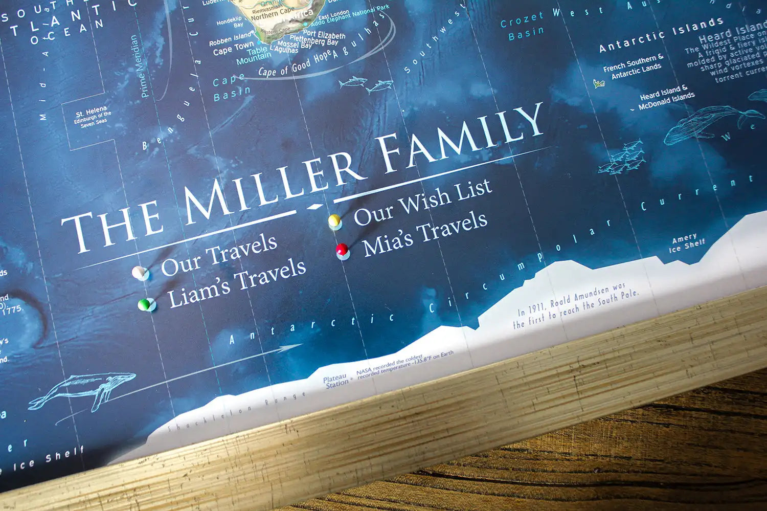
Personalize Your Map
Customize with quotes, legends, or dedications using "Personalize Map" options to craft your masterpiece map. Or reach out to us if you don't see the option you want.
We collaborate with you from design to approval of your proof so that you are 100% happy before we print and ship.
This topographic USA and National Parks Map, provides a comprehensive reference to the physical geography of the USA, plus over 600 National Park Sites, historical cities, landmarks, and interstates to plan and track your road trips.
Travel enthusiasts, students, and professionals alike understand the irreplaceable value of accurate, detailed maps. Whether you're an experienced explorer or just beginning your journey as a traveler, this USA travel destination map will ignite your passion to see, experience, and appreciate the stunning landscapes of our beautiful world.
Designed by a Professional Geographer and Cartographer
Comprehensive details and labeling
Geographically accurate and up-to-date references
Features over 600+ National Parks and Historical Sites
Made in the USA and crafted with high-quality USA Materials
Created by a professional geographer/cartographer. We worked with the National Park Service to uniquely display and reference over 600 sites across the USA. Every reference has been thoroughly researched, symbolized, and carefully labeled on the map. A unique colored-coded label and legend will guide you on the references.
This topographic map displays a striking 3D impression of the USA's elevation and terrain. Utilizing specialized GIS software and accurate USGS topological data, the map presents a visual depth that highlights deserts, valleys, mountains, plains, agricultural lands, and forested areas with natural landscape colorization.The unique color-coded labels and legend effortlessly guide your exploration of these sites.
Detailed USA Map Features:
✪ Over 600 National Park Service Sites (features all 63 National Parks and outlines the boundaries of each park) ✦ Interstate Roads to plan and reference ✦ Significant landmarks locations across the USA ✦ Labeled Major Rivers ✦ Historical Cities ✪ State Capitals Labeled ✪ NASA Visitor Centers
✦ Extraordinary Places (Meteor Crater, Mackinac Island, Niagara Falls, Mount Vernon and much more!) ▲Tallest peak in every state - numbered from the highest (1 in Alaska) to lowest elevation (50 in Florida). ▲10 of the most climbed peaks in the U.S. with the peak name and elevation in feet. ●●● For hikers, scout out the National Scenic Trails that cross the United States.
What sets our map apart:
What truly sets our maps apart is the depth of expertise and meticulous attention to detail that we bring to each creation. Our team's extensive background in Geography, Cartography, and GIS Data ensures that every map is not just a tool, but a comprehensive learning experience. As the leading Push Pin Map company in the USA—and indeed, globally—we pride ourselves on our commitment to in-depth research and advanced academic knowledge in the field.
Each map is crafted with precision and care, designed to evolve with you. As you explore and interact with our maps, you'll uncover layers of information and insights that enrich your understanding of the world.
Travel Bloggers, RV Campers, and Van Life Travelers: Our expertly crafted maps can significantly expand your reach, appealing to a broader audience that values quality and professionalism in travel planning and geographic education.
Perfect Gift for travelers, hikers, campers, students, history lovers, and geography enthusiasts. The content is recommended for adults and youth who would like to learn more about the USA.
Primary colors: Green, cream/white, purple, blue
Crafting Your Canvas Wrap Pin Map
Why choose GeoJango Maps?
We have a lifelong passion for maps, backed by 30+ years of cartography experience and Master's Degrees in Geographic Information Systems (GIS) from Penn State University and Environmental Science from the University of South Florida.
Our incredible investment into the design of our maps results in unparalleled detail that matters: they will educate you, and grow with you as you travel the world and track your travels—where other maps miss the mark.
We’ve built the leading map production studio in the USA and use exclusively USA-made materials. Each pin map is proudly crafted by hand, printed by us on the finest materials, mounted on museum-quality Gatorfoam, and carefully framed just for you.
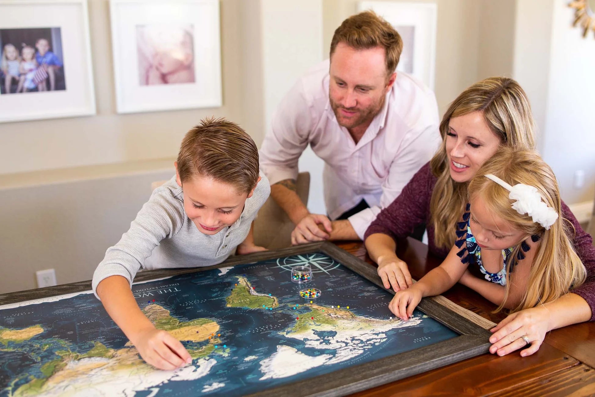
Push Pin Maps
Pin maps empower you to track your travels, and share your life story with everyone who sees your journeys laid out on a map! Beyond having an impressive work of scientific art in your home, you will be inspired to travel more, and feel the accomplishment of finally pinning your dream destinations, then again when you ignite conversation with everyone who sees it.
Canvas Wrap and Framed construction options are all crafted as pin maps - they include pins and will arrive to your door ready to hang. Rolled Posters are not crafted as pin maps, allowing you to find your own best way to display your travels.
The world is vast, and the size of your map significantly influences how you experience it: our most popular size is 36 inches!
Quality & Happiness Guarantee
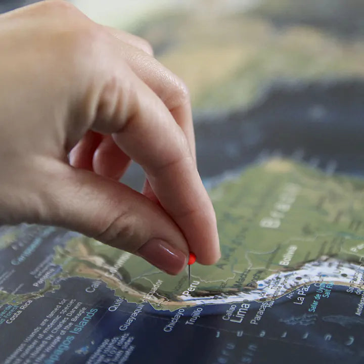
Pins Included With Pin Maps
Made In USA - Pleasanton, CA
Specs & Construction
Museum Quality Fine Art Production: We have built the finest map production studio in the USA, investing in the best printers and using only archival quality materials! We use specialized printing equipment that produces the finest quality prints to display clear labeling, vivid geography, and oceanography. If you are in the area, come visit us in Pleasanton, California!
Each of our maps are the product of years of research, backed by decades of professional GIS, cartography, and design experience. We keep no stock - every single map we produce is a custom production, made to order just for you. We love personalizing our maps to give you the highest quality experience.
Map Size Selection: The biggest factor in displaying a detailed map is the size. We can produce this map in these sizes: 24x16", 30x20", 36x24", 48x32", 60x40", and 72x48".
The 60x40" and 72x48" sizes are available as Rolled Prints or as a 3-Panel Canvas Wrap (premium and highest-quality craftsmanship).
The larger the size, the more impressive the display and view of the details in the map.
Need a small USA map that will fit in a limited space, the 24x16" and 30x20" inch size is so charming.
If you will be working with a local framer to display one of our paper or canvas posters in a custom frame, we will be able to accommodate any size between our standard offerings (though not deviating from our 1.5 aspect ratio), and include any margin you specify. Reach out to collaborate.
Framed Map Size vs. Outside Dimensions: Our sizing choices specify the size of the printed map itself. Our frame options will increase the overall size of your final product depending on your selection.
For example:
Maps sized 24 x 16 inches will total 26.5 x 18.5 inches with the frame
Maps sized 30 x 20 inches will total 34 x 24 inches with the frame
Maps sized 36 x 24 inches will total 40 x 28 inches with a selection of a 2-inch frame
Maps sized 48 x 32 inches will total 52 x 36 inches with a selection of a 2-inch frame
100% Made in the USA by a Small Women-Owned Business. What sets our business apart from most map companies: we are a team of professional Geographers, Cartographers, and Environmental Scientists. We have a passion for making maps and take the profession seriously - to produce beautiful and accurate maps. We apply thousands of layers using GIS and use optimal projections that reduce distortions. Special cartographic features are intricately made on the map and carefully labeled. We include special details that most of our competitors miss - such as real oceanography, accurate projections, and comprehensive labeling and referencing. Our passion and master craftsmanship make our map art stand out.
What's Included
What's Included with a Canvas Wrap or Framed Map: 500 Map pins and pin case. Each push pin map is individually made to order with archival quality materials. The print is mounted to gatorfoam pinboard, which will not warp, bend, or crush like cork or foamcore. We prepare the map with premium hanging hardware so you can start pinning your adventures immediately. This exclusive hanging solution keeps the map stable on your wall, even while pinning where you've been. The map is nicely packaged and shipped in a large box, ready to give as a gift.
What's Included with a Rolled Poster Map: Pins are not included by default, be sure to add pins in the order options if you plan to create your own push pin map. Gem stickers work well when the map isn't mounted to pin board. Consider adding a poster hanging kit to your order if you're not sure how you'll display your poster.
Poster Prints: Each one of our maps is crafted individually, unlike mass-produced alternatives.
Our posters are available in various sizes, all tailored to fit standard frames, we include an additional margin in the print to prevent coverage by the frame's lip. If you intend to DIY a push pin map with one of our posters, be sure to let us know in the order notes in your cart to adjust the print margins to your specs. To maintain the map's impeccable condition, it is carefully rolled with a robust tube, eliminating any possibility of folds or creases during transportation.
Each map is printed on fine-art paper or canvas with vivid, fade-free ink.
Construction
Canvas Wrap
Traditional stretched canvas in a gallery style wrap, with the art continuing over the sides. A modern, lightweight, floating look with a hidden internal frame and pin board.
Construction
Framed Map
Printed and mounted to archival quality rigid pin board, framed to put a focus on your journey.
Construction
Rolled Poster
Not looking for a push pin map? A rolled poster is an excellent project for you to find your own best way for you to display your wanderlust with your own frame!
Construction
Canvas Wrap
Traditional stretched canvas in a gallery style wrap, with the art continuing over the sides. A modern, lightweight, floating look with a hidden internal frame and pin board.
Framed Map
Printed and mounted to archival quality rigid pin board, framed to put a focus on your journey.
Rolled Poster
Not looking for a push pin map? A rolled poster is an excellent project for you to find your own best way for you to display your wanderlust with your own frame!
Support USA Small Business
All of our products are made entirely in the USA! Each map is hand crafted at our studio in Pleasanton, California. GeoJango is a woman-owned small business with expertise in GIS, Geography, Remote Sensing, Cartography, and Graphic Design. We blend science with art to visualize our beautiful planet. Our maps are designed to inspire people to learn more about the world.
FAQ
How are push pin maps made?
We make our maps at our studio in Pleasanton, California, USA. These are our works of art, and we craft each one to order - we do not keep stock products in inventory.
Each map is a product of years of research and design. We love the opportunity to combine science and art in these wonderful travel maps, and we especially love personalizing them just for you!
Your map will be produced to your specifications using our archival quality materials and fade-resistant inks on large format printers. If you choose a poster in canvas or paper it will be rolled and mailed to you. For ready-to-hang options in framed or stretched canvas, we will mount your map on archival quality pin board and include everything you need to start pinning and build lifelong memories.
We do not use foamcore or cork backing - the gatorfoam we mount pin maps to is a premium archival quality rigid material that will not warp over time, bend away, or crush as you pin your travels. Your pins will be held tight for a lifetime. This material also enables us to offer you incredible clarity with satin paper options that have a smooth finish, in addition to our canvas offerings.
Our canvas wrap and framed maps include premium hanging hardware as well. You will find the pre-installed rigid hangers make it easy for you to hang your map and keep it solidly level, and no guessing or measuring where to drill like for a wire!
Should I choose canvas or paper?
All of our push pin maps are mounted to archival quality pin boards. This premium, rigid material will not only hold your pins tight for a lifetime, but also provides a smooth surface that allows us to offer you smooth satin paper prints. In contrast to canvas there is no fabric weave visible, making text and other details clearer when printed at small sizes.
Canvas prints are better able to stand up to being touched, and allow us to offer the frameless stretched “canvas wrap” format at up to very large sizes.
We offer framing for both canvas and paper, and they both look incredible. From more than a couple feet away, the differences fall away, and either will earn you admiration as they hang from your wall.
Paper: better clarity of tiny details
Canvas: more options for sizing, better fingerprint resistance
Does this include map pins?
Pins are included with maps produced as push pin maps: canvas wrap and framed maps. We mount these maps to archival quality pin board so that they're ready to hang and begin tracking your lifetime of adventures.
Rolled posters do not include pins. These ship rolled in a tube for you to hang as a poster, purchase our poster hanging kit, make a DIY project, or contact a local framer. While we provide incredible quality with our push pin map production, many people do enjoy keeping rolled canvas posters as a traveling companion they can pack with them. If you would like to make your own pin board with one of our posters, be sure to add a pack of map pins to your order!
Will there be a hole if I remove a pin from my map?
Yes. Your mark on the world is permanent.
Our pin maps are produced with archival quality gatorfoam pin boards that will retain their shape over time, avoiding the issue of pins falling loose on their own like in common foamcore or cork boards. Push pin maps are made to be used!
When will my map arrive?
Maps without personalization will enter production right away. Poster will ship within one business day, while push pin formats may take one to three business days for us to craft to your specs.
If you request personalization options in your order you will receive an email from us with your proof - a preview of your map with your custom requests applied. Be on the lookout for this message (sent within one business day of your order), you must respond to it before we print and build your map. You can request additional changes and a new proof. After your approval your map will be crafted to your specs and shipped - within 1-3 days depending on the size of your order and our current volume.
We handcraft each of our maps at our studio in Pleasanton, California, USA. (Drop by if you're in the bay area!)
Standard shipping timeline in business days:
East Coast - 3-5 days after your map has shipped
Central - 2-4 days after your map has shipped
West Coast - 1-3 days after your map has shipped
How do I hang a map?
Framed and Canvas Wrap maps come pre-installed with unique rigid hangers, featuring an incredibly easy positioning process that'll keep your map level and steady even while you're placing your pins. Just have a hammer and some space on your wall ready. View our instructional video to learn more.
Poster options will additionally offer hanging kits, or you can keep it rolled for easy travel, or even take it on as a project to frame it yourself.
100%
of reviewers would recommend this product to a friend
7 Reviews
AW
Andrew W.Reviewed by Andrew W.
Verified Buyer
I recommend this product
Bought For
Personal Use
Pros
Unique
High Detail
High Quality
Worth the Price
Rated 5 out of 5
Review posted
Informative and Fun map
I respect all the research that went into the points of interest. Too many categories to list here, and the design really works well. It is difficult to fit in so much information without being too cluttered, but the GeoJango cartography pulls it off.
Loading...
Was this helpful?
MR
Morgan R.Reviewed by Morgan R.
Verified Buyer
I recommend this product
Rated 5 out of 5
Review posted
Well made
Love the case of 500 pins. The customer service is great and love the map. Better than expected.
Loading...
Was this helpful?
LH
Lee H.Reviewed by Lee H.
I recommend this product
Rated 5 out of 5
Review posted
Beautiful Design
We love the design and detail in the map. Our family loves it. My kids are having so much fun with it too.
Loading...
Was this helpful?
PM
Paul M.Reviewed by Paul M.
Verified Buyer
I recommend this product
Rated 5 out of 5
Review posted
Whole Family Loves it!
Fabulous design and the detail both maps. Looks great together in our dining room. We purchased the extra large 48x32 inch sized maps and couldn't be happier with how well they look together. The Farmhouse frames are beautiful. The finish on the maps are professional. The packaging was super too. They obviously took the time to make sure they were well protected for the shipping.
Loading...
Was this helpful?
PL
Pierre L.Reviewed by Pierre L.
Verified Buyer
I recommend this product
Bought For
Personal Use
Pros
Quick Shipping
Unique
High Quality
Rated 5 out of 5
Review posted
Really good experience
Communications were great.
Map is great. Well packed. Arrived in perfect condition. Exactly as promised.