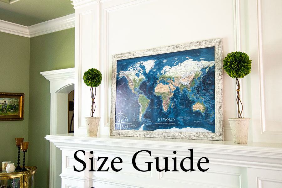
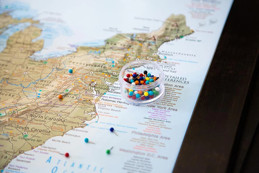
Filter

Sort by
Down
Travel Map Reviews
Second map I have brought for a friend. The quality is on that will pass down for many generations! Love it. Customer service is superb! No need to keep looking- this is the place for your next adventure map!!!!
— Minah Z.
The map is detailed and all the locations and geography that you would want for a world map. The labeling and visualization of the geography is stunning. We have the 48x32 inch size and think the price is well worth it. The pin board mounting is strong and looks fantastic. Top notch and worth every bit. Even the packaging was outstanding.
— Michael P.
My family loves the map. Its is the center of our dining room and the kids love picking places to visit.
— Holly M.
The details in the map are fantastic. It makes quite a feature and get a LOT of compliments on it.
— Bryan W.
We purchased the largest sized map and glad we did. It is stunning and looks like a piece of art. The pinboard is strong and won't crush. I was concerned if it would be too soft but found they have a higher quality than most shops. The packaging was solid and arrived safely and fast.
— Doreen E.
As world travelers, we wanted something to mark our memories. The details are extraordinary and we love the ability to see the ocean details. Perfect to mark our cruises.
— Mark S.
The details in the map are fantasic. We also go the Explorer Cards and love them too. The whole family is enjoying the map and having fun learning about geography.
— Olivia B.
World Maps Labeled for Exploration

Spreading the Joy of Travel

Explore the world with expert cartography - the product of 30+ years of passionate geographic research backed by Master's Degrees in Geographic Information Systems (GIS) from Penn State University and Environmental Science from University of South Florida.

We make the best maps, leveraging the beauty of geography to craft comprehensive labeled travel maps that are kept current with world events for all the thousands of locations we feature. Having one in your home will inspire you to travel more, and ignite conversation with everyone that visits!

Push Pin Travel Maps

What sets our push pin map apart: We are professional Geographers and GIS Scientists, and we take extraordinary time to make beautiful, accurate, comprehensive maps. Our maps feature real bathymetry, cultural references, landmarks, historical voyages, UNESCO World Heritage Sites, and much more! This enables you to tell your story as you pin your travels, tracking where you've been and where you aspire to go.

Explore the world with a framed pin board map or beautiful stretched canvas wall art. We invested in the best equipment and built the nation's best push pin map production center to ensure that your personalized map will last a lifetime. Our push pin map studio is located in Pleasanton, California, USA, where we produce museum-quality fine art maps, made to order just for you.

Learn With Labeled World Maps

How many countries are there in the world?

In 2024, there are 193 recognized countries in the United Nation’s official geographic database. The United Nations is an organization of independent States that was formed in 1945 under a Charter to promote and maintain international relations and peace. In addition to UN member states there are 2 non-member observer states: the State of Palestine, and Holy See, bringing the total to 195. Additionally there are quasi-states that meet the criteria for statehood, but not recognized by other states, such as Taiwan / Republic of China and the People’s Republic of China.

What is a country?

A country is an area of land with recognized boundaries and unified by one central government. The government represents the nation of people. Generally, the four characteristics of a country include

  1. an area of land that is defined by borders
  2. a permanent population
  3. a formal government
  4. sovereign territory that is diplomatically reinforced by one single independent government.

However, what specific areas constitute a country is an ever-evolving debate, with various regions claiming independence to varying degrees of recognition around the globe. The Holy See and Palestine, notable as UN observers, have wide recognition though are not UN members. Areas of disputed sovereignty have less recognition, such as Taiwan and Kosovo, which change over time.

Our world maps represent all of the countries using the United Nations geographic database.  However, there are many constraints when displaying the world as a flat rectangular wall map in a very small scale. The Earth covers 196.9 million square miles (510 million kilometers). Using GIS technology, we can reduce geographic features to a fraction to enable the visual display as a wall map. When appropriate, we must take measures to prioritize details in a map where labeling may obscure the visibility of the geography. We prioritize the visualization of features to enable a perspective of the location, size, and shape of areas. We apply comprehensive and modern projections that eliminate large exaggerations of lands such as Greenland when the Mercator projection is applied. Using two parallels at the 45-degree latitude on both the northern and southern hemispheres, we can optimize the visualization of the major bodies of land. Our projections are designed to prioritize the shape and area of land to maximize our visualization. 

How are push pin maps made?

We make our maps at our studio in Pleasanton, California, USA. These are our works of art, and we craft each one to order - we do not keep stock products in inventory.

Each map is a product of years of research and design. We love the opportunity to combine science and art in these wonderful travel maps, and we especially love personalizing them just for you!

Your map will be produced to your specifications using our archival quality materials and fade-resistant inks on large format printers. If you choose a poster in canvas or paper it will be rolled and mailed to you. For ready-to-hang options in framed or stretched canvas, we will mount your map on archival quality pin board and include everything you need to start pinning and build lifelong memories.

We do not use foamcore or cork backing - the gatorfoam we mount pin maps to is a premium archival quality rigid material that will not warp over time, bend away, or crush as you pin your travels. Your pins will be held tight for a lifetime. This material also enables us to offer you incredible clarity with satin paper options that have a smooth finish, in addition to our canvas offerings.

Our canvas wrap and framed maps include premium hanging hardware as well. You will find the pre-installed rigid hangers make it easy for you to hang your map and keep it solidly level, and no guessing or measuring where to drill like for a wire!

Cartography: Geographic World History

Learning geography and world history is an inherently intertwined process. As political and social movements lead to shifts in land ownership, the creation of new nations, and the redrawing of boundaries, these changes are meticulously documented through surveys and record keeping.

Historical events, from wars and treaties to exploration and colonization, directly influence geographical demarcations, thereby shaping the world map as we know it today. Meanwhile, the geographical context often plays a pivotal role in understanding the causes and outcomes of historical events, such as how mountain ranges have served as natural fortifications or how river valleys have cradled early civilizations. We invite you to explore the largest lakes in the world and learn about the physical geography of their formations as well as their bordering countries using GIS technology.

Together, the study of geography and world history provides a comprehensive view of humanity's footprint on the Earth. In our maps, we point out unique sites around the world that typically are not on most maps, yet these significant locations, such as the current 7 wonders of the world, are only a few examples. Using travel destination guides, interviewing world travelers, and through dedicated research, we highlight special sites around the world.

Gifts for travelers, history and geography fans alike, would enjoy exploring our Gallery of World Maps and Explorer Cards.

Types of World Maps

The details matter:  Our products are created by a professional Geographer and Cartographer who has the passion and experience, including Master's degrees in GIS and Environmental Science, to create impressive maps for your home or office. We understand the massive amount of accurate information necessary for a great map, so we highly recommend our maps — professionally designed with GIS.

The main differences are the colors and cartographic styles. The informative details (labeling) are the same throughout the maps with a few exceptions:  

The Voyager 2 includes snow/ice modeling. We use the MODIS satellite data collected in February to show the snow/ice cover on the landscape, which you can see represented in white in the northern hemisphere.

The Voyager 1 excludes the snow/ice modeling, so you can visualize the elevation and landscape of the terrain that lies beneath the snow cover.

The Magellan World Map features additional facts about Ferdinand Magellan's epic voyage around the world.

The Voyager, Nautilus, Magellan, Darwin, and Odyssey World Maps include modeling of the landscape and terrain (deserts, forests, flat lands, and more) and elevation features — which illustrate the mountainous regions. We applied a hillshade to model the sunlight at 3 p.m. consistently around the world. The hillshade provides a 3D effect. It is a flat surface — yet looks 3D due to the incredible modeling technique.

The Voyager, Nautilus, Magellan, and Odyssey World Maps include all 63 USA National Parks (as of 2024). In addition, all of these maps include renowned National Parks in several countries around the world.

The Endeavor, USS Enterprise, Humboldt, and Columbus World Maps provide a classic look at Earth without terrain modeling. Each of these maps depicts beautiful cartographic styles — from modern, sleek designs to antique-inspired designs that capture the character of old-world maps.  

All of our world maps feature our unique ocean floor elevation modeling derived from NOAA oceanic data. This data illustrates the formations of islands, archipelagos, plate tectonics, and ocean currents by displaying the sea floor elevation across the Earth's oceans.  

World Map Poster

We offer poster prints in canvas and paper, shipped rolled in a tube. While we love making pin board maps, our maps are comprehensive and will be useful in whatever way is important to you. Our posters are a great entry point to travel maps and are easy to take with you on your adventures (canvas will work best for packing). You may also DIY a display solution, choose from our poster hanger kits, or seek out a frame service local to you.

Framed World Map

You will find on our product pages a variety of framing options. Framed maps will ship ready to hang and include push pins so you can get started pinning your location easily. We have developed an incredibly unique and easy hanging solution which every framed map includes. These do not feature glazings unless the page states so or you request it - it would get in the way of the pins!

Stretched Canvas Map

Traditional stretched canvas in a gallery style wrap, with the art continuing over the sides. This format is lightweight at smaller sizes, and also is available at giant wall-spanning multi panel sizes.

The canvas is wrapped around a solid wood frame, premium pinboard, and is installed with our premium rigid hanging solution that makes it easy to mount on your wall.

Personalizing Your Map

All of our maps are handcrafted, made to order just for you, and we will work with you to craft your personal masterpiece map. Most of our map product pages will guide you through their options, but ALL of our maps can be customized. Include your quote, family names, or logo as directed, or reach out to our support for something special - we can also accept commissions for custom colorways!

All custom maps will receive a proof via email, and you will approve your proof before we print your map and begin crafting it to your specs. This will elevate your map to be an unforgettable gift, family heirloom, or personal travel diary.

World Map Poster and Framed Sizes

Our push pin maps are available in a variety of sizes, so we can
accommodate any space within your home or office. Take a look at this video to see a side-by-side comparison of our sizes.

The most important factor when choosing your map is size. The World is a huge place, but smaller prints like a world map poster are easy to travel with!

Map Finish Types

  • Framed satin paper or canvas mounted to pinboard
  • Stretched canvas with pinboard for a frameless gallery look
  • Rolled posters in paper or canvas for easy travel
  • Adhesive fabric or glossy wall coverings to transform an entire space in your home
A family pinning their world travel map

Custom Travel Map Gift

Maps are great for every age, gender, and occasion. Start an adventure, keep a push pin map as a touchable memory that can be personalized!

  • Perfect for wedding gifts
  • Lovely anniversary gifts  
  • Mother's Day Gifts or Father's Day Gifts
  • Graduation gifts for those just starting out in the world
  • Esteemed retirement gifts
  • Bucket List

Gift Wrap and nicely assembled card available for your gift.

Should I choose canvas or paper?

All of our push pin maps are mounted to archival quality pin boards. This premium, rigid material will not only hold your pins tight for a lifetime, but also provides a smooth surface that allows us to offer you smooth satin paper prints. In contrast to canvas there is no fabric weave visible, making text and other details clearer when printed at small sizes.

Canvas prints are better able to stand up to being touched, and allow us to offer the frameless stretched “canvas wrap” format at up to very large sizes.

We offer framing for both canvas and paper, and they both look incredible. From more than a couple feet away, the differences fall away, and either will earn you admiration as they hang from your wall.

  • Paper: better clarity of tiny details
  • Canvas: more options for sizing, better fingerprint resistance

How do I hang a map?

  • Framed and Canvas Wrap maps come pre-installed with unique rigid hangers, featuring an incredibly easy positioning process that'll keep your map level and steady even while you're placing your pins. Just have a hammer and some space on your wall ready. View our instructional video to learn more.
  • Poster options will additionally offer hanging kits, or you can keep it rolled for easy travel, or even take it on as a project to frame it yourself.

Will there be a hole if I remove a pin from my map?

Yes. Your mark on the world is permanent.

Our pin maps are produced with archival quality gatorfoam pin boards that will retain their shape over time, avoiding the issue of pins falling loose on their own like in common foamcore or cork boards. Push pin maps are made to be used!